A large part of rural areas is covered by forests or recreational areas. Rural areas are mainly characterized by forests (state forests, communal forests or private forests). Germany has about 11.4 million hectares, about one third of the area of Germany is forest. In times of increasing mechanization and growing demands in everyday life, these areas are becoming increasingly important for use in leisure time and as compensation areas for families and sports enthusiasts. At the same time, industrial forest management plays a major role in the use of renewable raw materials. The dangers to health and life in forest and natural areas are often underestimated, which can lead to minor but also serious injuries or death. At the same time, the reporting of accidents as well as the locating of the accident site and the recovery of accident victims is subject to natural restrictions. This ranges from the exact location in case of missing addresses, to the accessibility of the accident site due to the limited network of roads, to the rescue and recovery of persons.
The aim of the project is to improve the safety of the population through coordinated and standardized disaster and rescue management. The project should contribute to this,
- To be able to rescue people (forest workers, tourists, athletes) more quickly in emergencies,
- to better coordinate interventions in the event of natural disasters (forest fires, floods, forest rupture due to storm damage) or other catastrophic events.
Project Outline
Forests and recreational areas are increasingly becoming a space in which both private individuals spend their leisure time and companies with the task of managing them spend more time. The forest as a source of renewable resources is an increasing factor for forestry management. For leisure users, growing urbanization is an important incentive to seek balance in nature. It is not uncommon for sports to be practised with an increased risk. This development is accompanied by a number of incalculable dangers and risks, which are often underestimated by the people living in forests and recreational areas.
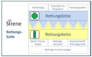
The aim of the project is the development, testing and dissemination of a telematically supported rescue chain suite, which enables the rescue forces and other BOS organs to quickly reach the scene of complex operations in the forest or open corridor. A main component of this suite is the so-called "rescue controller", which triggers the operation and enables the emergency forces to navigate on non-public roads. In addition to analog map guidance, this will also be done electronically using special navigation devices (BOS-Navi). The integration of the rescue forces into the digital information flow provides an important advantage for the guidance of the emergency forces. Using a routing system with information on the quality of the access paths in the forest, the best and fastest escape route is determined and the emergency vehicle piloted. A large number of players may be involved in the rescue. For them, a standardized procedure for handling such rescue operations ("rescue chain") must be developed, tested in a pilot phase and transferred to disaster operations.
The background of the SiReNe project is the "Forest Rescue Chain", by which the process of all assistance necessary to rescue and care for injured persons from the forest is understood. Health care and hazard prevention is carried out by the legislative competence of the federal states. In order to establish the basic and practical requirements for such a system and its performance, we are dependent on the knowledge and experience of experts.
The project is not commercially oriented and does not primarily pursue economic goals. The project results serve to support and further qualify the rescue service in Germany as a public task of state health care and danger prevention for its citizens. It strives for a holistic, integrative IT package with the help of which the rescue chain can become more efficient even in remote areas. Rough key points and possibilities:
- Measures for improved location localization in the area of mobile communications
- Core program with standards-based geodata services, standardized process model, mobile radio technology - integrative and interactive
- For the first time routable path network in forests and recreation areas with attributes for trafficability etc.
- Increasing the density of rescue points or establishing them outside wooded areas
- Integrative routing software solution in emergency vehicles
- Testing in test scenarios in rural and urban areas
The project results serve to support and further qualify the rescue service in Germany as a public task of state health care and danger prevention for its citizens. The technical components to be developed and the competences generated form the basis of business models which are to serve as innovation drivers both in the region and in the federal state of Hesse.
Project partners
The project SiReNE - Safety and rescue in nature and recreation areas with navigation-controlled process chains is a project to be implemented by the federal state of Hesse.
SiReNE is funded by the Hessen Agentur GmbH and implemented by the Frankfurt University of Applied Sciences - Professorship for Geoinformatics, the Curatorship for Forest Work and Technology (KWF), the NavLog GmbH, the Hessian Administration for Soil Management and Geoinformation (HVBG).
Contact
Project organisation/coordination, transfer, external presentation


